Vedant Mayfair stands at Vasant Valley, Hill Road, Khadakpada, Kalyan (West) 421301, near Vibgyor School and close to Godrej Hill. It is in Thane district, inside the Mumbai Metropolitan Region. Listing portals also file the sub-locality as Gandhar Nagar, which is the same address under a different label.
The address
| Street | Vasant Valley, Hill Road, Khadakpada |
|---|---|
| Locality | Kalyan West 421301 |
| Sub-locality | Gandhar Nagar, as used by listing portals |
| Nearest landmark | Vibgyor School |
| District and region | Thane, Mumbai Metropolitan Region |
| MahaRERA | PR1330002502871 |
What the developer's map names around the site
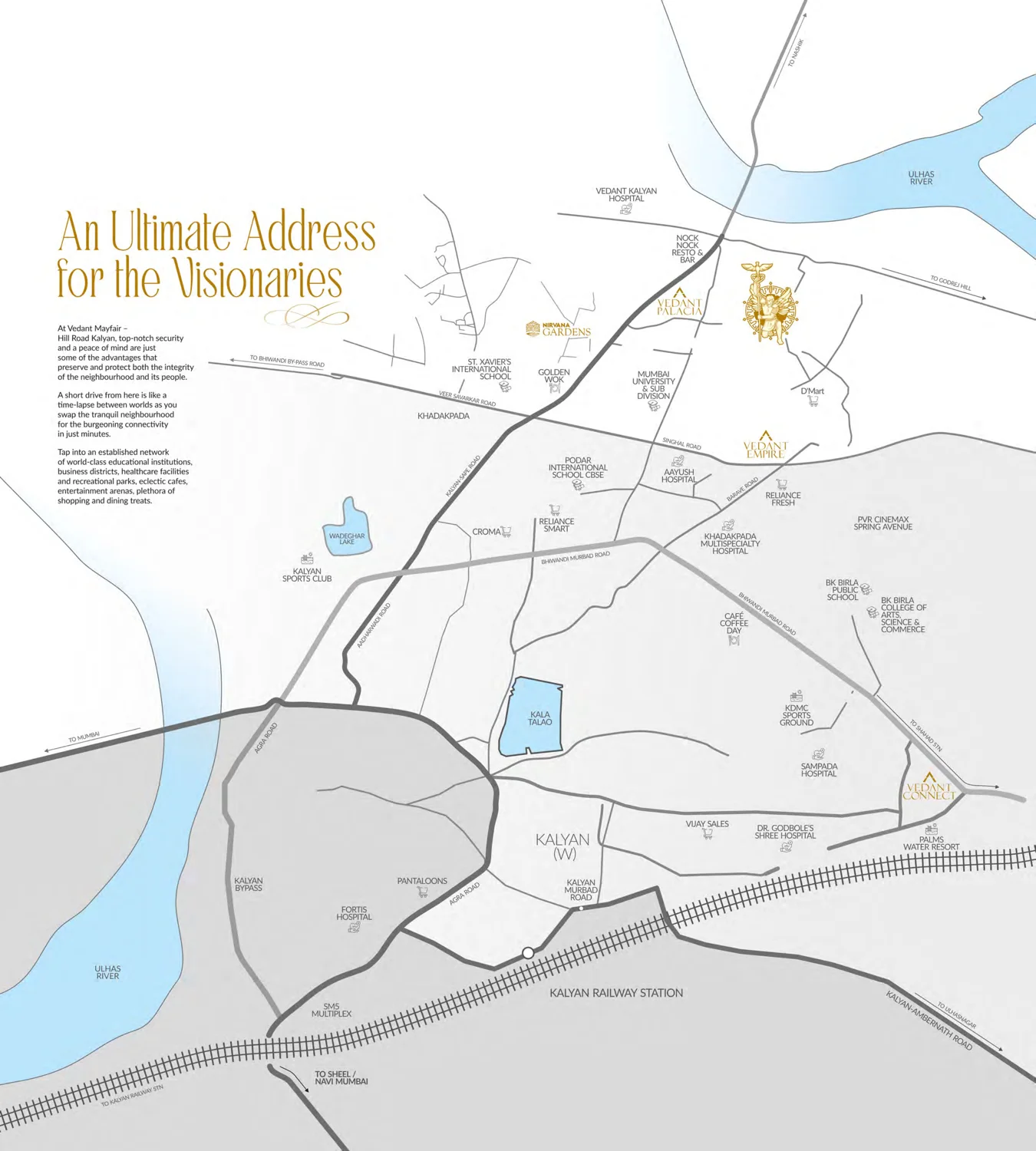
The locality map in the e-brochure names the following. This is the developer's own list, not ours, and it is a map rather than a measured drive-time table.
- Schools. Vibgyor School is the nearest landmark to the site. The map also shows St. Xavier's International School, Podar International School CBSE, BK Birla Public School and BK Birla College of Arts, Science and Commerce.
- Health. Vedant Kalyan Hospital, Khadakpada Multispecialty Hospital, Aayush Hospital, Sampada Hospital, Dr. Godbole's Shree Hospital and Fortis Hospital.
- Higher education. Mumbai University's Kalyan sub division.
- Open space and water. Wadeghar Lake, Kala Talao and the Ulhas River.
- Retail and leisure. D'Mart, Reliance Smart, Reliance Fresh, Croma, Pantaloons, Vijay Sales, PVR Cinemax Spring Avenue, SM5 Multiplex, Kalyan Sports Club, KDMC Sports Ground, Palms Water Resort, Nock Nock Resto and Bar, Golden Wok and Cafe Coffee Day.
- Road and rail. The map places the site between Veer Savarkar Road and the Bhiwandi Murbad Road, with the Kalyan Bypass and Agra Road to the south west and Kalyan Railway Station about the same distance to the south.
Drive times are on request, measured from the plot itself and stamped with the time of day they were measured. A published drive time is usually taken from a locality centroid at a convenient hour, and none of those survive a Kalyan weekday evening.
The nine regional projects on the developer's connectivity board
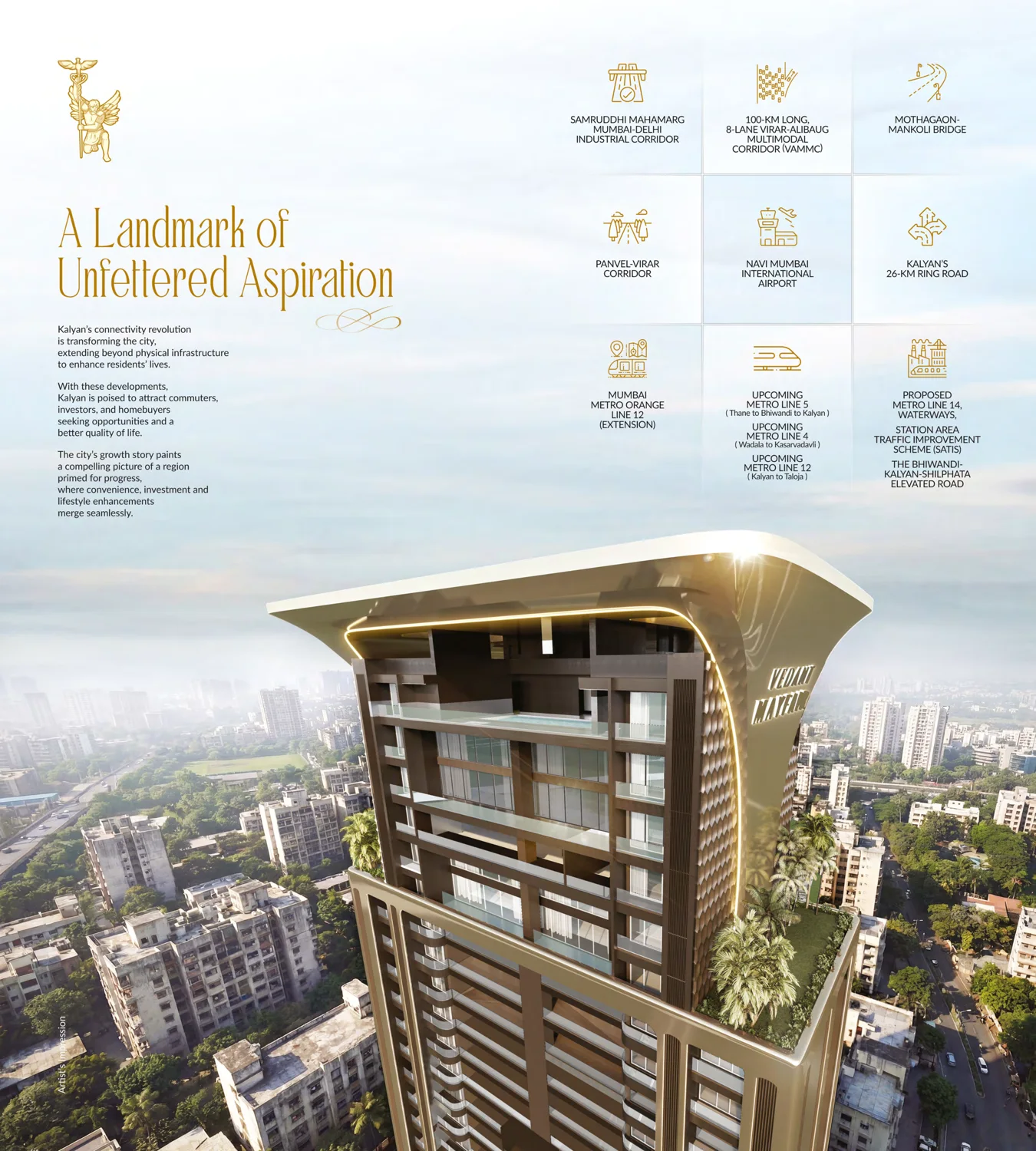
Page 8 of the e-brochure sets out nine infrastructure projects under the heading "Kalyan's connectivity revolution". Here they are, in the brochure's own words, with our note on each about what stage it is actually at. We attach no completion date to any of them, and we would treat any page that does with suspicion.
| Samruddhi Mahamarg | The Mumbai to Delhi industrial corridor. Sections of the Mumbai to Nagpur expressway are operational. |
|---|---|
| Virar-Alibaug Multimodal Corridor | Described in the brochure as 100 km long and 8 lane. Under development, with land acquisition and construction running in phases. |
| Mothagaon-Mankoli Bridge | A Kalyan to Bhiwandi river crossing intended to take pressure off the existing route. |
| Panvel-Virar Corridor | A planned rail corridor across the eastern and western halves of the region. |
| Navi Mumbai International Airport | Under construction at Ulwe, roughly 40 km south of Kalyan by road. |
| Kalyan's 26 km Ring Road | A municipal ring road project for Kalyan Dombivli. |
| Mumbai Metro Orange Line 12, extension | The Kalyan to Taloja line. The brochure lists both the Orange Line 12 extension and, separately, Metro Line 12 as upcoming. |
| Upcoming Metro Lines 5, 4 and 12 | Line 5 Thane to Bhiwandi to Kalyan, Line 4 Wadala to Kasarvadavli, Line 12 Kalyan to Taloja. At varying stages of construction and approval. |
| Proposed Metro Line 14, waterways, SATIS and the Bhiwandi-Kalyan-Shilphata elevated road | Grouped by the brochure itself as proposed. The Station Area Traffic Improvement Scheme and the elevated road are the two with the most direct bearing on a Kalyan commute. |
Read that list the way a buyer should, not the way a brochure intends. Announced infrastructure is not running infrastructure, and in this region the gap between the two has historically been measured in years, sometimes in decades. Several of the nine above are genuinely under construction; several are proposals with no funded timeline. Buy the building and the address on their own merits, and treat every line in that table as upside rather than as part of the case.
Khadakpada as an address
Khadakpada is the established residential side of Kalyan West, on the Kalyan road network with Godrej Hill alongside, and it is where the district's schools, hospitals and older housing stock have concentrated. What it has had less of is large-format housing. A single tower with two homes on a floor, four and five bedroom residences and a 20,000 sq ft clubhouse is a different product from most of what has been built here, and that, rather than the locality itself, is the reason to look at it.
Judge it from the plot
A 39 storey tower cannot be assessed from a map or a render. What the plot actually faces, what will be built next to it, where the sun lands on which side in the afternoon, and how the approach road behaves at 7 pm are all things you can only learn by standing there. We will send the exact location pin, the approach from your side of the city, and arrange a slot with the developer's sales team.
Verify the promoter entity, the sanctioned plan, the unit count and the declared completion date on the MahaRERA certificate for PR1330002502871 before you book.Questions
Where exactly is Vedant Mayfair located?
At Vasant Valley, Hill Road, Khadakpada, Kalyan (West) 421301, near Vibgyor School and close to Godrej Hill, in Thane district within the Mumbai Metropolitan Region. Listing portals also tag the sub-locality as Gandhar Nagar, which is the same address under a different label.
What schools and hospitals are near Vedant Mayfair?
The locality map in the developer's e-brochure names Vibgyor School as the nearest landmark, with St. Xavier's International School, Podar International School CBSE, BK Birla Public School and BK Birla College nearby. For health it names Vedant Kalyan Hospital, Khadakpada Multispecialty Hospital, Aayush Hospital, Sampada Hospital, Dr. Godbole's Shree Hospital and Fortis Hospital. It also shows Mumbai University's Kalyan sub division, Wadeghar Lake, Kala Talao and D'Mart.
Is the metro coming to Khadakpada, Kalyan West?
The developer's connectivity board lists the Mumbai Metro Orange Line 12 extension, upcoming Metro Lines 5, 4 and 12, and a proposed Metro Line 14. Line 12 runs Kalyan to Taloja and Line 5 runs Thane to Bhiwandi to Kalyan. They are at varying stages of approval and construction, we attach no completion date to any of them, and we would treat any page that quotes one with caution.
Get the location pin and a site visit
The exact coordinates, the approach from your side of the city, and a slot to walk the plot at Vasant Valley, Hill Road, Khadakpada.
Request a callback